![]()
![]()
![]()
![]()
![]()
![]()
![]()
![]()
![]()
![]()
 |
|
Lancashire Hills, Long
Mynd-Shropshire, Roundway-Devizes,
White Horse - Westbury,
Rhossili-S Wales
|
|
|
| Parlick, Beacon Fell, Longridge, Bull Pot, Pendle Hill, Rivington Pike & Winter Hill |

|
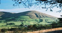
Parlick:
Suitable for NW-S-ENE winds. (Os map 102)
Sometimes called Parlick Pike, it is situated approx 10 miles N.E of Preston. Nearest Village is Chipping, Parlick covers the majority of local prominent wind directions. NW through S to NE, almost 270 Degrees of good lift conditions. We generally do not from the top of Parlick. W - NW site; GR SD5937 4500 - We fly from the Dry stone wall adjacent to the path Suggest you do not go up the main face of Parlick, its a scarily steep hill. once through the gate at Fell Foot Cottage, Follow the diagonal footpath to left (West). follow the upward spiralling footpath about 500m to the kissing gate - great views of the west coast while you walk. The site is a short distance along the path after the gate situated behind the stone wall. (for more info - see below: ) SW - SE site; -along path from GR SD5937 4475 to SD 5980 4500. for South West winds, Flying from the top gully, or just above it which traverse from the westerly path to the Southerly main face gully. For Southerly or South Easterly winds fly from the path which traverses from the top of the main face gully (the one you can see from Fell Foot gate) to the East face. SE - ENE site; - GR SD 6000 4500. Flying from the plateau on the East side. put your gear in the gullies adjacent to the path -keeps everyhing out of the wind..
Direct route - Strenuous walk- Turn right at Fell Foot & take path, not shown on OS maps - in NE direction. After about 300m take feint track to left rising steeper & eventually arriving at bomb hole.
Indirect route - A much easier walk, a little further but you will be glad you took this route. Follow the path as if going to the Westerly slope. Once you see the kissing gate, stop, there is a gully on your right hand side. climb up onto the edge of the gully and follow across the fell main face. Once you reach the main face gully, which you see from the fell foot gate, cross the main path and onto the Easterly path which will lead you along the south face, (which we can fly when the wind is South East to South) and onto the east face. Fairly strenuous walk to the different sites. Excellent Lift, Landings can be difficult with models over 3m due to slope of fell. Usually good smooth lift on all faces.
Parlick is shared with full size gliders & paragliders. There is also an unofficial group of model fliers - The Parlick Soarers, a name established by many retired modellers that used to meet up on Wednesdays and who had flown there for decades. The slopes are now frequented by a smaller number of stalwart modellers who are prepared to take a good walk and benefit from the excellent lift available. Directions: Route 1 (A6 from Preston) (Map - Red route) At Junction 1 of the M55 roundabout (Preston) take the A6 heading North on the new Broughton ring road (James Towers Way) towards Garstang / Lancaster A6. Turn right at the Roundabout signposted Longridge B5269. Take a left after 1mile (Langley Lane) and head through Inglewhite. continue past Barns Fold reservoirs & continue in a NE direction passing the Gliding club on the left & generally heading towards Chipping. The road to Fell Foot is to the left about 1ml after the Gliding club. Route 2 (A6 from Lancaster)
(Map - Yellow route) Park in the parking bays up the access road to fell foot or at the junction at the bottom. .GR 60004437. Walk up the access road to Fell Foot cottage where there is a large gate. Remember, this is a public area frequented by ramblers, and the skies are frequented by full size gliders and paragliders. This is where you may think
that you want to go home – the thought of climbing straight up
to the top hill from here puts a lot of people off. However,
model flying is generally not done from the top and depending on
the direction of the wind then the walk may not be quite as bad
as you think to the areas where modellers gather. |
Parlick
MAP
Click on MAP for directions (1.4Mb)
|
|||
|
Beacon Fell: Suitable for SW-NW winds. (OS map 102)
|
|
|||
|
Longridge Fell: (Jeffrey Hill); (Map - Green route) Suitable for N - NNW winds. Park at GR SD 6400 4012. Fly at GR SD6440 4040.
Easy walk from car park - through the gate, followed by gentle incline on the well defined path. Fairly good landing areas - some rocks in heather - good for large models. Site also shared with para gliders.
As you progress through the Style /
Gate from the carpark, some locals prefer to fly on the edge of the
green grass meadow to the left. At the bottom Right hand corner of
the meadow area, there is a some reed grass and a gulley / peat
cutting, great for getting out of the wind. But this a little too
close to the road some 50 feet below you at this point. But landing
used to be good on the meadow patch, but this now has many patchy
clumps of reed grass to catch out the un-weary. Most land in the
reed bed to right of the area now. Watch out for the sheep
droppings! Direction: At Junction 1 of the M55 roundabout (Preston) Take the A6 heading North on the new Broughton ring road (James Towers Way) towards Garstang / Lancaster A6. Halfway along the ring road, turn right at the Roundabout signposted Longridge. B5269 At Longridge, do not go into the town centre but continue over the mini roundabout and on until the junction where the main road veers right and down the hill towards Ribchester. (There is a pub on the junction at this point). Turn left here ( Higher Road) and continue towards the Longridge Golf club. Again the road forks – take the LH fork -sign posted golf club. Continue past the golf club and you will come to a single large cottage at a “T” junction. Turn right up the hill and you will see a car park on the left. You are there!
What you will now see is
Beacon Fell to the NW, the associated range of hill to the north of the Forest of Bowland, Parlick, Snape
Fell, Wolf Fell etc. In the distance to the NE, North Yorkshire
moors.
|
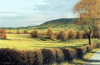
Jeffrey Hill
View from Jeffrey Hill - Parlick in the distance
|
|||
|
(Lat 54.212741, Long -2.508211) Park GR SD6430 7925.
Walk a few metres up hill from car park lay-by & enter gate on right. Site is a few metres easy walk from gate at GR SD6435 7905. Usually good lift with good landing areas - suitable for large models. Lift can be lumpy as wind moves round to east. Well worth a visit.
|
||||
|
Pendle Hill (Lat
53.843240° Long -2.345080°) (Grid Ref SD771385) Flying site is primarily the "Nick of Pendle" catering for W to NNW and SSE to SSW
Ribble Valley Model Soaring Association
|
||||
|
Situated to the NE of Horwich, Nr Bolton, just off the M61. Winter Hill can be seen for miles around as it is the hill with the TV Mast situated on top.
Rivington Soaring Association fly at three main sites and caters for:
|
Rivington - Location | |||
| Shropshire |
|
|||
|
Direction: Head for Church Stretton situated on the A49 approx 10 mile south of Shrewsbury. Turn into the town at the traffic lights, the Spar shop is on the left if you need supplies for the day ahead. Head into the town centre at the Cross roads go straight over and head up the Burway to the top of the Long Mynd.
Be careful going up the Burway, its a single track with passing places, but it does go up the side of the valley and gets quite steep. There is a full size gliding club on the top, and they do take the glider trailers up and down this way.
There are a number flying site at the top. The first is the "Reservoir Slope" (NE) situated on the right of the main track. Shortly followed by "Ashes Hollow" (SE) on the left. Carry on this road heading for the Gliding Club and you will come across a copse of tree on the right and a car park. This is "Pole Cottage" (W), just a short flat walk from the car park. Other slope are "Ashlet" (E) and "Darnford" (N)
Visit the Long Mynd Soaring Association Website for More Direction
|
Wikipedia - Church Stretton | |||
|
Staffordshire - Bordering on the Peak District |
|
|||
|
Leek & Moorland - Leek & Moorland Model Gliding Association 7 Flying sites around the area |
|
|||
|
|
||||
|
Wiltshire - |
|
|||
|
Roundway,or Oliver's Hill (Devizes)(S - W)
Situated just North of Devizes, in Wilstshire.
At the Travel lodge/Subway sandwich shop (SN10 2HL), situated on a junction on the A361 (London Road) North of the Town of Devizes, turn onto Folly road and continue until you reach a junction (no through road) with a red post box and old phone box in the village of Roundway. Turn right and follow road up the hill until the road splits (you will see a white horse carved into the hill on the right. Don't go to the white horse, but turn onto the left hand fork road. Follow this to the top until the tarmac stops, you will see a track running along the ridge to the left. follow this track (Its quite bumpy so take it easy. At the end of the track park your car near the woods. the path is to the right of the woods a level walk for a 100 meters or so and you will emerge at the top of the Roundway. |
|
|||
|
White Horse (Westbury) (NW - N) (E)
Situated South East of Westbury, From the B3098, Bratton Road (SW Westbury), at the Cross roads of Alfred Street and Newtown, turn onto Newtown and follow Road up the hill. The road bears left on to Long River Road, continue and turn left onto top of hill and the White horse. The extensive carpark is also on the top. Range of hills takes a NW round to a N, there is also a gully / bowl that allows for and Easterly wind |
Lat/Long 51°15′49″N 002°08′49″W
|
|||
|
Somerset |
|
|||
|
Crook Peak, West Mendip Hills |
||||
|
|
||||
|
Wales |
|
|||
|
Rhossili Down (W) Worm Head Cliffs (SW)
Situated on the Gower Peninsula, to the West of Swansea. (Lat 51.56856°N, Long 4.28690°W)
from Swansea Head towards the Mumbles, Turn on to the B4436. turn left on to the A4118 then right onto B4247 for Rhossili. these are genreeal direction, please check the map as it is quite a way from Swansea.
At Rhossili, head towards Worm Head and park in the car park, or you can park in the church car park for a gratuity From here you will see Rhossili Bay and the huge hill overlooking the fantastic beach.
Head up the hill from the church, there is a small plateau half way up. this is where the para glider school launch from. Proceed to the top and the model gliding and para gliding from the Westerly slope nearest to work Head. Fantastic lift that extends a long way out, with no turbulence and plenty of flat space to land behind, with no hint of turbulence. A Dream Slope soaring venue as long as you have a Westerly wind.
The cliffs to the south of Worm Head can also be soared with smaller models (SW to WSW). Be careful though as conditions can be turbulent at times.
Situated on the Gower Peninsula, to the West of Swansea.
|
|
|||
| The BWLCH |
|
|||
|
|
||||
|
|
||||
|
|